Posts in category ”Digital maps”
Found 6 hits, currently showing 1-6.
Travel map of Anthony Bourdain
I was a bit surprised to discover that a new season of Parts Unknown will start this weekend. Since, you know, the leading man Anthony Bourdain is unfortunately not with us anymore.

Realistic subway maps
Subway maps are usually meant as a visual guide to the system and not by any means an accurate map of the real city. What seems close on a tube map could very likely be a large distance in the real world.

The world of digital map mashups
The world of mashups didn’t stop at the infamous projects HousingMaps or Chicago crime map. It goes on and on with stuff such as Weatherbonk and the Where to go travel map.

Manhattan elsewhere
For all of you who share my love for both Manhattan and digital maps, I want direct your attention to Jason Kottke’s latest project called Manhattan Elsewhere.
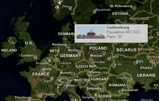
Atlas demo with Europe map
Last month saw the April CTP release of Atlas, Microsoft’s upcoming framework for Ajax applications. I’ve done a small live demonstration with ASP.NET 2.0, which show a basic map display with pinpointed locations of the largest cities in Europe.

Google Maps goes photographic
Yesterday Google updated their web application Google Maps, now including satellite photos from DigitalGlobe and Earthsat, covering United States and Canada.